
Topografische Karte City of Fulton
Interaktive Karte
Klicken Sie auf die Karte, um die Höhe anzuzeigen.
Über diese Karte
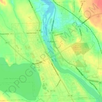
Name: Topografische Karte City of Fulton, Höhe, Relief.
Durchschnittliche Höhe: 114 m
Minimale Höhe: 88 m
Maximale Höhe: 143 m
Andere topografische Karten
Klicken Sie auf eine Karte, um ihre Topografie, ihre Höhe und ihr Relief anzuzeigen.
Town of Mexico
United States > New York > Oswego County
Town of Mexico, Oswego County, New York, 13114, United States
Durchschnittliche Höhe: 119 m
Village of Cleveland
United States > New York > Oswego County > Town of Constantia
Village of Cleveland, Town of Constantia, Oswego County, New York, United States
Durchschnittliche Höhe: 134 m
Town of Williamstown
United States > New York > Oswego County
Town of Williamstown, Oswego County, New York, 13493, United States
Durchschnittliche Höhe: 235 m
Village of Central Square
United States > New York > Oswego County > Village of Central Square
Village of Central Square, Town of Hastings, Oswego County, New York, United States
Durchschnittliche Höhe: 126 m
Town of Granby
United States > New York > Oswego County
Town of Granby, Oswego County, New York, 13115, United States
Durchschnittliche Höhe: 125 m