
Topografische Karte Carmel
Interaktive Karte
Klicken Sie auf die Karte, um die Höhe anzuzeigen.
Über diese Karte
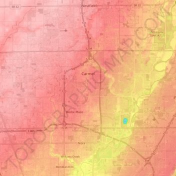
Name: Topografische Karte Carmel, Höhe, Relief.
Ort: Carmel, Hamilton County, Indiana, United States (39.92604 -86.24107 40.00312 -86.02352)
Durchschnittliche Höhe: 253 m
Minimale Höhe: 153 m
Maximale Höhe: 288 m
Andere topografische Karten
Klicken Sie auf eine Karte, um ihre Topografie, ihre Höhe und ihr Relief anzuzeigen.
Noblesville
United States > Indiana > Hamilton County
Noblesville, Hamilton County, Indiana, 46060, United States
Durchschnittliche Höhe: 249 m
Boxley
United States > Indiana > Hamilton County
Boxley, Hamilton County, Indiana, United States
Durchschnittliche Höhe: 283 m
Arcadia
United States > Indiana > Hamilton County
Arcadia, Hamilton County, Indiana, United States
Durchschnittliche Höhe: 262 m
Fishers
United States > Indiana > Hamilton County
Fishers, Hamilton County, Indiana, United States
Durchschnittliche Höhe: 246 m
Westfield
United States > Indiana > Hamilton County
Westfield, Hamilton County, Indiana, 46074, United States
Durchschnittliche Höhe: 269 m
creek
United States > Indiana > Hamilton County > Westfield
creek, Westfield, Hamilton County, Indiana, United States
Durchschnittliche Höhe: 279 m
Lake Ullswater
United States > Indiana > Hamilton County > Carmel
Lake Ullswater, Carmel, Hamilton County, Indiana, United States
Durchschnittliche Höhe: 274 m
Carmel
United States > Indiana > Hamilton County > Carmel > Carmel
Carmel, Hamilton County, Indiana, 46032-1361, United States
Durchschnittliche Höhe: 254 m
Noblesville
United States > Indiana > Hamilton County
Noblesville, Hamilton County, Indiana, 46060, United States
Durchschnittliche Höhe: 241 m
Sheridan
United States > Indiana > Hamilton County > Sheridan
Sheridan, Hamilton County, Indiana, United States
Durchschnittliche Höhe: 290 m