
Spenden
Topografische Karte Ballyhaise
Klicken Sie auf die Karte, um die Höhe anzuzeigen.
Spenden
Ballyhaise
Ballyhaise Bridge was built around 1710 by Colonel Brockhill Newburgh. It is made from roughly coursed limestone elevations which have elliptical arches having cut-stone arch rings. The bridge was positioned on a central axis with Ballyhaise House, which acts as a reminder of the formally laid out demesne. Its location across the Annalee River was a priority link between Cavan Town and County Monaghan. The new route enabled an accessible passage for goods in and out of the village.
Spenden
Über diese Karte
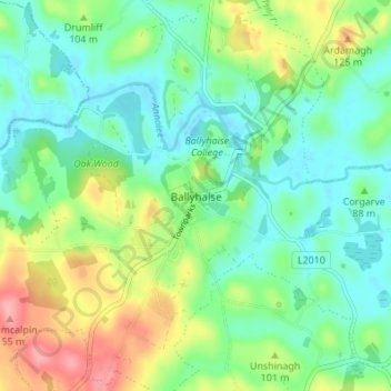
Name: Topografische Karte Ballyhaise, Höhe, Relief.
Durchschnittliche Höhe: 82 m
Minimale Höhe: 50 m
Maximale Höhe: 148 m
Spenden
Andere topografische Karten
Klicken Sie auf eine Karte, um ihre Topografie, ihre Höhe und ihr Relief anzuzeigen.
Spenden
Shercock
The region is known as "Drumlin Country" owing to its topography of small hills and lakes formed at the end of the last ice age. County Cavan borders County Fermanagh and County Monaghan. Together, they form the colloquially named "Drumlin County". Shercock lies on the border between County Cavan and County…
Durchschnittliche Höhe: 117 m
Spenden
Spenden
Spenden
Spenden
Spenden
Spenden
Spenden
Spenden
Spenden
Spenden
Spenden
Spenden
Spenden