
Topografische Karte Calvià
Klicken Sie auf die Karte, um die Höhe anzuzeigen.
Calvià
Calvià first appears in history as a village 2,000 years BCE, although the area was first populated in the Neolithic Era. Later, sailors coming from the east stopped in the Balearics on their way to the Iberian Peninsula, where they sought metals. They came from Italy, from other Mediterranean islands, and from the Near East, and constructed small settlements along the coast. Historians call this period the "Cave Culture", because caves were frequently used as habitations and burial areas. Some vestiges of this area have been catalogued in an archaeological excavation called the Puig de sa Morisca Archaeological Park, which conserves remains of what was a talaiot 9 metres (30 ft) in diameter. It is located on a small mountainous elevation in Calvià's Santa Ponsa district.
Über diese Karte
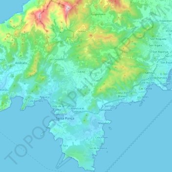
Name: Topografische Karte Calvià, Höhe, Relief.
Ort: Calvià, Serra de Tramuntana, Balearic Islands, Spain (39.45671 2.42185 39.64237 2.59803)
Durchschnittliche Höhe: 134 m
Minimale Höhe: -1 m
Maximale Höhe: 1.017 m
Andere topografische Karten
Klicken Sie auf eine Karte, um ihre Topografie, ihre Höhe und ihr Relief anzuzeigen.
Puig Major
Spain > Balearic Islands > Serra de Tramuntana > Escorca
Puig Major is the highest peak on the Spanish island of Majorca. With an elevation of 1,436 m (4,711 ft) above sea level. It is situated in the Serra de Tramuntana mountains. As the mountain is located in a military zone, the neighbouring peak Puig de Massanella (1,364 m) is considered the highest accessible…
Durchschnittliche Höhe: 949 m
Serra de Tramuntana
Spain > Balearic Islands > Serra de Tramuntana
The climate in the Tramuntana Range is significantly wetter than the rest of the island, recording as much as 1507 mm (59.3 inches) of precipitation per year, in comparison with some other parts of the island where annual rainfall is less than 400mm (15 inch). It is also cooler due to the altitude, and a few…
Durchschnittliche Höhe: 175 m
Mirador d'es Colomer
Spain > Balearic Islands > Serra de Tramuntana > Port de Pollença
Durchschnittliche Höhe: 79 m
Pla dels Egües
Spain > Balearic Islands > Serra de Tramuntana > Pollença
Durchschnittliche Höhe: 248 m
Cova de ses Bruixes
Spain > Balearic Islands > Serra de Tramuntana > Pollença
Durchschnittliche Höhe: 143 m
Serra de Tramuntana
Spain > Balearic Islands > Serra de Tramuntana
The climate in the Tramuntana Range is significantly wetter than the rest of the island, recording as much as 1507 mm (59.3 inches) of precipitation per year, in comparison with some other parts of the island where annual rainfall is less than 400mm (15 inch). It is also cooler due to the altitude, and a few…
Durchschnittliche Höhe: 175 m