
Spenden
Topografische Karte Subangdaku
Klicken Sie auf die Karte, um die Höhe anzuzeigen.
Spenden
Subangdaku
It is one of the two (the other one being the municipality of Consolacion) local government units located within the mainland Metro Cebu where the elevation of land is less than 100 m (330 ft).
Spenden
Über diese Karte
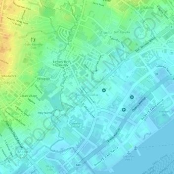
Name: Topografische Karte Subangdaku, Höhe, Relief.
Ort: Subangdaku, Mandaue, Central Visayas, Philippines (10.31414 123.91869 10.33453 123.93074)
Durchschnittliche Höhe: 10 m
Minimale Höhe: -4 m
Maximale Höhe: 32 m
Spenden
Andere topografische Karten
Klicken Sie auf eine Karte, um ihre Topografie, ihre Höhe und ihr Relief anzuzeigen.
Canduman
It is one of the two (the other one being the municipality of Consolacion) local government units located within the mainland Metro Cebu where the elevation of land is less than 100 m (330 ft).
Durchschnittliche Höhe: 37 m