
Vielen Dank für die Unterstützung dieser Website ❤️
Spenden
Spenden
Topografische Karte Bandipura
Klicken Sie auf die Karte, um die Höhe anzuzeigen.
Vielen Dank für die Unterstützung dieser Website ❤️
Spenden
Spenden
Über diese Karte
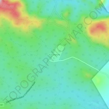
Name: Topografische Karte Bandipura, Höhe, Relief.
Durchschnittliche Höhe: 1.012 m
Minimale Höhe: 941 m
Maximale Höhe: 1.199 m
Vielen Dank für die Unterstützung dieser Website ❤️
Spenden
Spenden
Andere topografische Karten
Klicken Sie auf eine Karte, um ihre Topografie, ihre Höhe und ihr Relief anzuzeigen.
Bandipur National Park/Tiger Reserve
India > Karnataka > Gundlupet taluk
Durchschnittliche Höhe: 860 m
Bandipur National Park
India > Karnataka > Gundlupet taluk
Bandipur National Park is located between 75° 12’ 17" E to 76° 51’ 32" E and 11° 35’ 34" N to 11° 57’ 02" N where the Deccan Plateau meets the Western Ghats, and the altitude of the park ranges from 680 m (2,230 ft) to 1,454 m (4,770 ft). As a result, the park has a variety of biomes including dry…
Durchschnittliche Höhe: 860 m