
Vielen Dank für die Unterstützung dieser Website ❤️
Spenden
Spenden
Topografische Karte Olinda
Klicken Sie auf die Karte, um die Höhe anzuzeigen.
Vielen Dank für die Unterstützung dieser Website ❤️
Spenden
Spenden
Olinda
The average elevation is 16 m above sea level. The landscapes is made of plains and hills, some of them steep. Olinda is mostly drained by the Paratibe River (55.13% of the territory), with the remainder drained by the Capibaribe River. The municipality is in the Atlantic Forest ecoregion.
Vielen Dank für die Unterstützung dieser Website ❤️
Spenden
Spenden
Über diese Karte
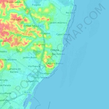
Name: Topografische Karte Olinda, Höhe, Relief.
Durchschnittliche Höhe: 9 m
Minimale Höhe: -2 m
Maximale Höhe: 64 m
Vielen Dank für die Unterstützung dieser Website ❤️
Spenden
Spenden
Andere topografische Karten
Klicken Sie auf eine Karte, um ihre Topografie, ihre Höhe und ihr Relief anzuzeigen.
Praça Farias Neves
Brazil > Pernambuco > Região Metropolitana do Recife > Recife
Durchschnittliche Höhe: 22 m
Ana de Alburquerque
Brazil > Pernambuco > Região Metropolitana do Recife > Igarassu
Durchschnittliche Höhe: 17 m