
Spenden
Topografische Karte La Sage
Klicken Sie auf die Karte, um die Höhe anzuzeigen.
Spenden
Über diese Karte
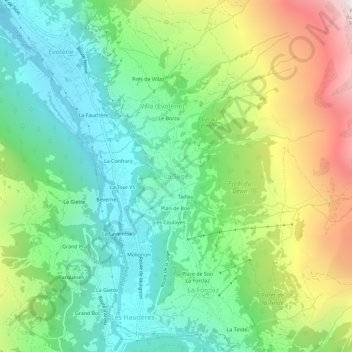
Name: Topografische Karte La Sage, Höhe, Relief.
Ort: La Sage, Evolène, Hérens, Wallis, 1983, Switzerland (46.07876 7.49470 46.11876 7.53470)
Durchschnittliche Höhe: 1.889 m
Minimale Höhe: 1.326 m
Maximale Höhe: 2.976 m
Spenden
Andere topografische Karten
Klicken Sie auf eine Karte, um ihre Topografie, ihre Höhe und ihr Relief anzuzeigen.
Evolène
Switzerland > Wallis > Hérens
At precisely 8.27 pm, the first two avalanches were set off on the slopes above Villa, at an altitude around 2,600 m (8,500 ft). They were a combination of fresh powder snow and established spring snow and demolished all trees and chalets in their path, as well as the people unlucky enough to be in the chalets…
Durchschnittliche Höhe: 2.697 m
Spenden