Geolokalisieren
👉 Easily get elevation data in JSON, GeoTIFF and KML formats using Elevation API
Vielen Dank für die Unterstützung dieser Website ❤️
Spenden

Topografische Karte Bayeux

Klicken Sie auf die Karte, um die Höhe anzuzeigen.

👉 Easily get elevation data in JSON, GeoTIFF and KML formats using Elevation API
Vielen Dank für die Unterstützung dieser Website ❤️
Spenden

Bayeux

Bayeux is located 7 kilometres (4 miles) from the coast of the English Channel and 30 km (19 mi) north-west of Caen. The city, with elevations varying from 32 to 67 metres (105 to 220 feet) above sea level – with an average of 46 metres (151 feet) – is bisected by the River Aure. Bayeux is located at the crossroads of RN 13 and the train route Paris-Caen-Cherbourg. The city is the capital of the Bessin, which extends north-west of Calvados. Bayeux station has rail connections to Caen, Cherbourg, Granville and Paris.

Wikipedia (CC-BY-SA 3.0)

👉 Easily get elevation data in JSON, GeoTIFF and KML formats using Elevation API
Vielen Dank für die Unterstützung dieser Website ❤️
Spenden

Über diese Karte

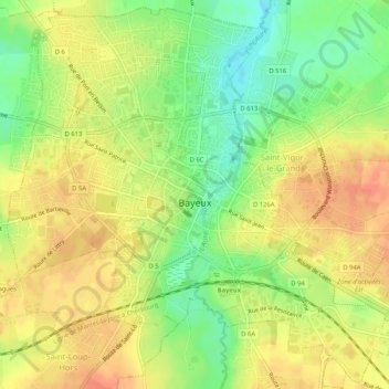
Name: Topografische Karte Bayeux, Höhe, Relief.

Ort: Bayeux, Calvados, Normandy, Metropolitan France, 14400, France (49.26081 -0.72757 49.29347 -0.67574)

Durchschnittliche Höhe: 55 m

Minimale Höhe: 30 m

Maximale Höhe: 73 m

👉 Easily get elevation data in JSON, GeoTIFF and KML formats using Elevation API
Vielen Dank für die Unterstützung dieser Website ❤️
Spenden

Andere topografische Karten

Klicken Sie auf eine Karte, um ihre Topografie, ihre Höhe und ihr Relief anzuzeigen.

Pointe du Hoc

France > Normandy > Calvados > Cricqueville-en-Bessin > Le Guay

Durchschnittliche Höhe: 11 m

Le Pont du Hable

France > Normandy > Calvados > Cricqueville-en-Bessin

Durchschnittliche Höhe: 7 m

La Folie

France > Normandy > Calvados > Moulines

Durchschnittliche Höhe: 145 m

Juno Beach

France > Normandy > Calvados > Courseulles-sur-Mer

Durchschnittliche Höhe: 4 m

Vielen Dank für die Unterstützung dieser Website ❤️
Spenden

La Renoullière

France > Normandy > Calvados > Noues de Sienne

Durchschnittliche Höhe: 261 m

Le Domaine

France > Normandy > Calvados > Basseneville

Durchschnittliche Höhe: 8 m

Hasting

France > Normandy > Calvados > Dives-sur-Mer

Durchschnittliche Höhe: 32 m

Les Panniers

France > Normandy > Calvados > Saint-Jouin

Durchschnittliche Höhe: 80 m

Vielen Dank für die Unterstützung dieser Website ❤️
Spenden

Mont Pinçon

France > Normandy > Calvados > Les Monts d'Aunay

Durchschnittliche Höhe: 284 m

Merville

France > Normandy > Calvados > Merville-Franceville-Plage

Durchschnittliche Höhe: 8 m

Les Manoirs

France > Normandy > Calvados > Glanville > Les Manoirs

Durchschnittliche Höhe: 96 m

Vielen Dank für die Unterstützung dieser Website ❤️
Spenden