
Spenden
Topografische Karte Santo Antônio do Pinhal
Klicken Sie auf die Karte, um die Höhe anzuzeigen.
Spenden
Santo Antônio do Pinhal
Santo Antônio do Pinhal is a municipality in the state of São Paulo in Brazil. It is part of the Metropolitan Region of Vale do Paraíba e Litoral Norte. The population is 6,827 (2020 est.) in an area of 133.01 km². The elevation is 1,080 m (3543 ft). It is situated near Campos do Jordão, some 150 km away from São Paulo.
Spenden
Über diese Karte
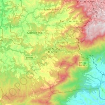
Name: Topografische Karte Santo Antônio do Pinhal, Höhe, Relief.
Durchschnittliche Höhe: 1.126 m
Minimale Höhe: 571 m
Maximale Höhe: 1.870 m
Spenden
Andere topografische Karten
Klicken Sie auf eine Karte, um ihre Topografie, ihre Höhe und ihr Relief anzuzeigen.
Ilha Sumítica
Brazil > São Paulo > Região Metropolitana do Vale do Paraíba e Litoral Norte > Ilhabela
Durchschnittliche Höhe: 1 m
Ilha Sumítica
Brazil > São Paulo > Região Metropolitana do Vale do Paraíba e Litoral Norte > Ilhabela
Durchschnittliche Höhe: 1 m
Pedra do Baú
Brazil > São Paulo > Região Metropolitana do Vale do Paraíba e Litoral Norte > São Bento do Sapucaí
At its highest point, the elevation is 1,950 metres (6,400 ft).
Durchschnittliche Höhe: 1.502 m
Morro do Pico Agudo
Brazil > São Paulo > Região Metropolitana do Vale do Paraíba e Litoral Norte > Paraibuna
Durchschnittliche Höhe: 1.056 m
Spenden
Serra do Roncador
Brazil > São Paulo > Região Metropolitana do Vale do Paraíba e Litoral Norte > Monteiro Lobato
Durchschnittliche Höhe: 846 m
Praça Barão do Rio Branco
Brazil > São Paulo > Região Metropolitana do Vale do Paraíba e Litoral Norte > Jacareí
Durchschnittliche Höhe: 581 m
Ilha Sumítica
Brazil > São Paulo > Região Metropolitana do Vale do Paraíba e Litoral Norte > Ilhabela
Durchschnittliche Höhe: 1 m
Paiol Grande
Brazil > São Paulo > Região Metropolitana do Vale do Paraíba e Litoral Norte > São Bento do Sapucaí
Durchschnittliche Höhe: 1.339 m
Spenden
São José dos Campos
Brazil > São Paulo > Região Metropolitana do Vale do Paraíba e Litoral Norte
In the urban area, there are rolling plateaus and hills. The lowest elevation in the city (and also in the municipality) is found in the Paraíba do Sul River, at a mean elevation of 550 m.
Durchschnittliche Höhe: 634 m
Rio Paraíba do Sul
Brazil > São Paulo > Região Metropolitana do Vale do Paraíba e Litoral Norte > Guaratinguetá
Durchschnittliche Höhe: 546 m