
Topografische Karte Vyšná Rybnica
Interaktive Karte
Klicken Sie auf die Karte, um die Höhe anzuzeigen.
Über diese Karte
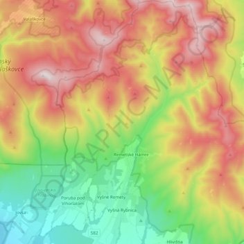
Name: Topografische Karte Vyšná Rybnica, Höhe, Relief.
Durchschnittliche Höhe: 538 m
Minimale Höhe: 109 m
Maximale Höhe: 1.047 m
The village lies at an altitude of 222 metres and covers an area of 40.082 km². It has a population of 375 people.
Andere topografische Karten
Klicken Sie auf eine Karte, um ihre Topografie, ihre Höhe und ihr Relief anzuzeigen.
Sobrance
Slovakia > Region of Košice > District of Sobrance
Sobrance, District of Sobrance, Region of Košice, Eastern Slovakia, 073 01, Slovakia
Durchschnittliche Höhe: 124 m