
Topografische Karte Del Gallego
Interaktive Karte
Klicken Sie auf die Karte, um die Höhe anzuzeigen.
Über diese Karte
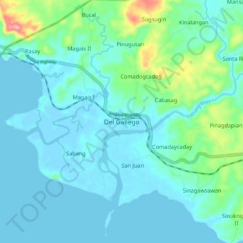
Name: Topografische Karte Del Gallego, Höhe, Relief.
Ort: Del Gallego, Camarines Sur, Bicol Region, Philippines (13.88258 122.55381 13.96258 122.63381)
Durchschnittliche Höhe: 29 m
Minimale Höhe: -2 m
Maximale Höhe: 181 m
Andere topografische Karten
Klicken Sie auf eine Karte, um ihre Topografie, ihre Höhe und ihr Relief anzuzeigen.
Mount Labo
Philippines > Camarines Sur > Del Gallego
Mount Labo, Del Gallego, Camarines Sur, Bicol Region, Philippines
Durchschnittliche Höhe: 539 m
Kinalangan
Philippines > Camarines Sur > Del Gallego > Kinalangan
Kinalangan, Del Gallego, Camarines Sur, Bicol Region, Philippines
Durchschnittliche Höhe: 62 m
Mount Labo
Philippines > Camarines Sur > Del Gallego
Mount Labo, Del Gallego, Camarines Sur, Bicol Region, Philippines
Durchschnittliche Höhe: 1.058 m