
Topografische Karte Oxford
Interaktive Karte
Klicken Sie auf die Karte, um die Höhe anzuzeigen.
Über diese Karte
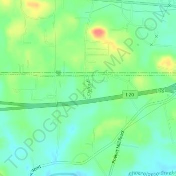
Name: Topografische Karte Oxford, Höhe, Relief.
Ort: Oxford, Talladega County, Alabama, United States (33.58227 -85.94320 33.58566 -85.94146)
Durchschnittliche Höhe: 190 m
Minimale Höhe: 168 m
Maximale Höhe: 231 m
Andere topografische Karten
Klicken Sie auf eine Karte, um ihre Topografie, ihre Höhe und ihr Relief anzuzeigen.
Mignon
United States > Alabama > Talladega County > Mignon
Mignon, Talladega County, Alabama, 35150, United States
Durchschnittliche Höhe: 173 m
Childersburg
United States > Alabama > Talladega County
Childersburg, Talladega County, Alabama, United States
Durchschnittliche Höhe: 146 m
Talladega
United States > Alabama > Talladega County
Talladega, Talladega County, Alabama, United States
Durchschnittliche Höhe: 191 m
The Moon
United States > Alabama > Talladega County > Sylacauga
The Moon, Sylacauga, Talladega County, Alabama, 35150, United States
Durchschnittliche Höhe: 199 m
Munford
United States > Alabama > Talladega County > Munford
Munford, Talladega County, Alabama, 36268, United States
Durchschnittliche Höhe: 191 m
Saint Ives
United States > Alabama > Talladega County
Saint Ives, Talladega County, Alabama, United States
Durchschnittliche Höhe: 157 m