
Topografische Karte Majuli
Interaktive Karte
Klicken Sie auf die Karte, um die Höhe anzuzeigen.
Über diese Karte
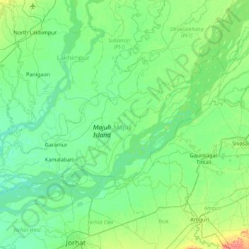
Name: Topografische Karte Majuli, Höhe, Relief.
Ort: Majuli, Assam, 785104, India (26.86653 93.95991 27.18552 94.59583)
Durchschnittliche Höhe: 90 m
Minimale Höhe: 73 m
Maximale Höhe: 169 m
Andere topografische Karten
Klicken Sie auf eine Karte, um ihre Topografie, ihre Höhe und ihr Relief anzuzeigen.
Barangajuli
India > Assam > Harisinga tehsil
Barangajuli, Harisinga tehsil, Udalguri District, Assam, 784526, India
Durchschnittliche Höhe: 117 m
North Lakhimpur
North Lakhimpur, Lakhimpur, Assam, India
Durchschnittliche Höhe: 92 m
Sarthebari
India > Assam > Sarthebari > Sarthebari
Sarthebari, Bajali, Assam, 781307, India
Durchschnittliche Höhe: 41 m
Jorhat
India > Assam > Jorhat East
Jorhat, Jorhat East, Jorhat, Assam, 785001, India
Durchschnittliche Höhe: 93 m
Dibrugarh West
India > Assam > Dibrugarh West
Dibrugarh West, Dibrugarh, Assam, India
Durchschnittliche Höhe: 100 m