
Spenden
Topografische Karte Malolos
Klicken Sie auf die Karte, um die Höhe anzuzeigen.
Spenden
Malolos
Malolos is relatively flat of about 0.81% to a gently sloping of 2.17%. The slope of the land descends towards west, southwest to southern direction. The highest land elevation is at about 6.0 meters above sea level while the lowest is only half a meter below sea level. A network of natural waterways and rivers of various sizes and importance is traversing through the landscape of the town down south to Manila Bay.
Spenden
Über diese Karte
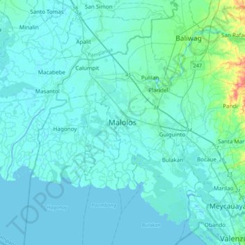
Name: Topografische Karte Malolos, Höhe, Relief.
Ort: Malolos, Bulacan, Central Luzon, 3000, Philippines (14.68376 120.65137 15.00376 120.97137)
Durchschnittliche Höhe: 6 m
Minimale Höhe: -3 m
Maximale Höhe: 74 m
Spenden
Andere topografische Karten
Klicken Sie auf eine Karte, um ihre Topografie, ihre Höhe und ihr Relief anzuzeigen.
Marina Lake
Philippines > Bulacan > San Jose del Monte > Sapang Palay Proper
Durchschnittliche Höhe: 50 m
Biak na Bato National Park
Philippines > Bulacan > Doña Remedios Trinidad > Talbak
Durchschnittliche Höhe: 127 m
Spenden
Doña Remedios Trinidad
List of highest peaks in D.R.T by elevation.
Durchschnittliche Höhe: 172 m