
Topografische Karte Augusta
Interaktive Karte
Klicken Sie auf die Karte, um die Höhe anzuzeigen.
Über diese Karte
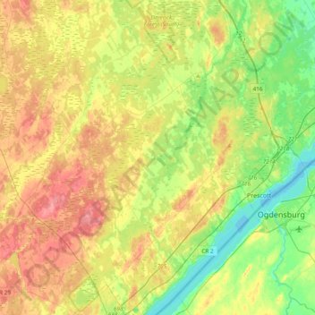
Name: Topografische Karte Augusta, Höhe, Relief.
Durchschnittliche Höhe: 103 m
Minimale Höhe: 72 m
Maximale Höhe: 140 m
Andere topografische Karten
Klicken Sie auf eine Karte, um ihre Topografie, ihre Höhe und ihr Relief anzuzeigen.
Pittston
Canada > Ontario > Leeds and Grenville Counties > Edwardsburgh/Cardinal
Durchschnittliche Höhe: 82 m
Cockburn Island
Canada > Ontario > Leeds and Grenville Counties > Elizabethtown-Kitley
Durchschnittliche Höhe: 112 m
St. Helena Island
Canada > Ontario > Leeds and Grenville Counties > Front of Yonge
Durchschnittliche Höhe: 115 m
Kemptville
Canada > Ontario > Leeds and Grenville Counties > North Grenville
Durchschnittliche Höhe: 97 m
Mallorytown
Canada > Ontario > Leeds and Grenville Counties > Front of Yonge
Durchschnittliche Höhe: 98 m
Waterton
Canada > Ontario > Leeds and Grenville Counties > Leeds and the Thousand Islands > Waterton
Durchschnittliche Höhe: 97 m
Seeleys Bay
Canada > Ontario > Leeds and Grenville Counties > Leeds and the Thousand Islands > Seeley's Bay
Durchschnittliche Höhe: 105 m