Geolokalisieren
👉 Easily get elevation data in JSON, GeoTIFF and KML formats using Elevation API
Vielen Dank für die Unterstützung dieser Website ❤️
Spenden

Topografische Karte Rio Unhais

Klicken Sie auf die Karte, um die Höhe anzuzeigen.

👉 Easily get elevation data in JSON, GeoTIFF and KML formats using Elevation API
Vielen Dank für die Unterstützung dieser Website ❤️
Spenden

Über diese Karte

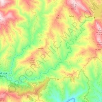
Name: Topografische Karte Rio Unhais, Höhe, Relief.

Ort: Rio Unhais, Pampilhosa da Serra, Coimbra, Portugal (40.03914 -7.96023 40.08879 -7.85862)

Durchschnittliche Höhe: 596 m

Minimale Höhe: 282 m

Maximale Höhe: 946 m

👉 Easily get elevation data in JSON, GeoTIFF and KML formats using Elevation API
Vielen Dank für die Unterstützung dieser Website ❤️
Spenden

Andere topografische Karten

Klicken Sie auf eine Karte, um ihre Topografie, ihre Höhe und ihr Relief anzuzeigen.

Folgares

Portugal > Coimbra > Pampilhosa da Serra

Durchschnittliche Höhe: 371 m

Janeiro de Baixo

Portugal > Coimbra > Pampilhosa da Serra

Durchschnittliche Höhe: 520 m

Vidual

Portugal > Coimbra > Pampilhosa da Serra

Durchschnittliche Höhe: 775 m

Vielen Dank für die Unterstützung dieser Website ❤️
Spenden

Fajão

Portugal > Coimbra > Pampilhosa da Serra

Durchschnittliche Höhe: 790 m

Sobral de Cima

Portugal > Coimbra > Pampilhosa da Serra

Durchschnittliche Höhe: 519 m

Porto da Balsa

Portugal > Coimbra > Pampilhosa da Serra

Durchschnittliche Höhe: 769 m

Portela do Fojo

Portugal > Coimbra > Pampilhosa da Serra

Durchschnittliche Höhe: 436 m

Vielen Dank für die Unterstützung dieser Website ❤️
Spenden

Lobatinhos

Portugal > Coimbra > Pampilhosa da Serra

Durchschnittliche Höhe: 518 m

Machialinho

Portugal > Coimbra > Pampilhosa da Serra > Janeiro de Baixo

Durchschnittliche Höhe: 489 m

Esteiro

Portugal > Coimbra > Pampilhosa da Serra > Janeiro de Baixo

Durchschnittliche Höhe: 436 m

Vidual

Portugal > Coimbra > Pampilhosa da Serra

Durchschnittliche Höhe: 795 m

Vielen Dank für die Unterstützung dieser Website ❤️
Spenden

Castanheira da Serra

Portugal > Coimbra > Pampilhosa da Serra

Durchschnittliche Höhe: 845 m

Unhais-o-Velho

Portugal > Coimbra > Pampilhosa da Serra

Durchschnittliche Höhe: 790 m

Ceiroquinho

Portugal > Coimbra > Pampilhosa da Serra

Durchschnittliche Höhe: 697 m

Foz do Ribeiro

Portugal > Coimbra > Pampilhosa da Serra > Cabril

Durchschnittliche Höhe: 623 m

Vielen Dank für die Unterstützung dieser Website ❤️
Spenden

Vale Serrão

Portugal > Coimbra > Pampilhosa da Serra

Durchschnittliche Höhe: 622 m

Armadouro

Portugal > Coimbra > Pampilhosa da Serra > Cabril

Durchschnittliche Höhe: 615 m

Lobatos

Portugal > Coimbra > Pampilhosa da Serra

Durchschnittliche Höhe: 531 m

Cavaleiros de Baixo

Portugal > Coimbra > Pampilhosa da Serra

Durchschnittliche Höhe: 581 m

Vielen Dank für die Unterstützung dieser Website ❤️
Spenden

Trinhão

Portugal > Coimbra > Pampilhosa da Serra

Durchschnittliche Höhe: 481 m

Fajão

Portugal > Coimbra > Pampilhosa da Serra

Durchschnittliche Höhe: 666 m

Pessegueiro

Portugal > Coimbra > Pampilhosa da Serra

Durchschnittliche Höhe: 617 m