
Spenden
Topografische Karte Show Low
Klicken Sie auf die Karte, um die Höhe anzuzeigen.
Spenden
Show Low
Show Low is a city in Navajo County, Arizona. It lies on the Mogollon Rim in east central Arizona, at an elevation of 6,345 feet (1,934 m). The city was established in 1870 and incorporated in 1953. According to the 2010 census, the population of the city was 10,660.
Spenden
Über diese Karte
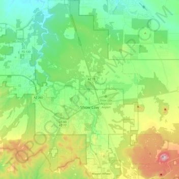
Name: Topografische Karte Show Low, Höhe, Relief.
Ort: Show Low, Navajo County, Arizona, 85901, United States (34.18376 -110.10385 34.35921 -109.94456)
Durchschnittliche Höhe: 1.957 m
Minimale Höhe: 1.794 m
Maximale Höhe: 2.309 m
Spenden
Andere topografische Karten
Klicken Sie auf eine Karte, um ihre Topografie, ihre Höhe und ihr Relief anzuzeigen.
Three Sisters
United States > Arizona > Navajo County
The area is part of the Colorado Plateau. The elevation of the valley floor ranges from 5,000 to 6,000 feet (1,500 to 1,800 m) above sea level. The floor is largely siltstone of the Cutler Group, or sand derived from it, deposited by the meandering rivers that carved the valley. The valley's vivid red color…
Durchschnittliche Höhe: 1.667 m