
Spenden
Topografische Karte Belterra
Klicken Sie auf die Karte, um die Höhe anzuzeigen.
Spenden
Belterra
Belterra was founded as a rubber plantation, after the economic failure of Fordlândia, which had been founded in 1928 by Henry Ford. The intention of the US-Department of Commerce in the 1920s was to produce rubber in Brazil and to import it to USA. The advantage of the Belterra plantation over the plantation of Fordlândia 100 km (62 mi) to the south is the flat topography, which enables the use of machinery. In its peak time in the late 1930s some 50 km2 (19 sq mi) were cultivated with Hevea brasiliensis (rubber tree).
Spenden
Über diese Karte
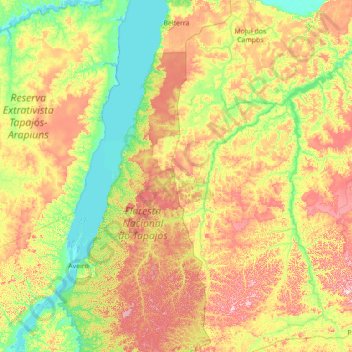
Name: Topografische Karte Belterra, Höhe, Relief.
Durchschnittliche Höhe: 107 m
Minimale Höhe: -2 m
Maximale Höhe: 316 m
Spenden
Andere topografische Karten
Klicken Sie auf eine Karte, um ihre Topografie, ihre Höhe und ihr Relief anzuzeigen.
Amazon River
During what many archaeologists called the formative stage, Amazonian societies were deeply involved in the emergence of South America's highland agrarian systems. The trade with Andean civilizations in the terrains of the headwaters in the Andes formed an essential contribution to the social and religious…
Durchschnittliche Höhe: 4 m
Amazon River
During what many archaeologists called the formative stage, Amazonian societies were deeply involved in the emergence of South America's highland agrarian systems. The trade with Andean civilizations in the terrains of the headwaters in the Andes formed an essential contribution to the social and religious…
Durchschnittliche Höhe: 9 m
Spenden
Amazon River
During what many archaeologists called the formative stage, Amazonian societies were deeply involved in the emergence of South America's highland agrarian systems. The trade with Andean civilizations in the terrains of the headwaters in the Andes formed an essential contribution to the social and religious…
Durchschnittliche Höhe: 19 m
Spenden
Amazon River
During what many archaeologists called the formative stage, Amazonian societies were deeply involved in the emergence of South America's highland agrarian systems. The trade with Andean civilizations in the terrains of the headwaters in the Andes formed an essential contribution to the social and religious…
Durchschnittliche Höhe: 5 m
Spenden