
Topografische Karte Ciudad Juárez
Interaktive Karte
Klicken Sie auf die Karte, um die Höhe anzuzeigen.
Über diese Karte
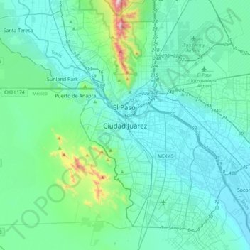
Name: Topografische Karte Ciudad Juárez, Höhe, Relief.
Durchschnittliche Höhe: 1.218 m
Minimale Höhe: 1.105 m
Maximale Höhe: 2.034 m
Due to its location in the Chihuahuan Desert and high altitude, Ciudad Juárez has a cold desert climate (Köppen: BWk). Seasons are distinct, with hot summers, mild springs and autumns, and cold winters. Summer average high is 35 °C (95 °F) with lows of 21 °C (70 °F). Winter highs average 14 °C (57 °F) with lows of 0 °C (32 °F). Rainfall is scarce and greater in summer. Snowfalls occur occasionally (about 4 times a year), between November and March. On December 26/27, 2015, parts of the city received 40 cm (16 in) of snow within a 24-hour period beating the previous record of 28 cm (11 in) set in 1951. The record high is 49 °C (120 °F) and the record low is −23 °C (−9 °F).