
Topografische Karte Frahan
Interaktive Karte
Klicken Sie auf die Karte, um die Höhe anzuzeigen.
Über diese Karte
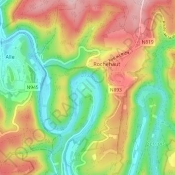
Name: Topografische Karte Frahan, Höhe, Relief.
Durchschnittliche Höhe: 291 m
Minimale Höhe: 184 m
Maximale Höhe: 431 m
Andere topografische Karten
Klicken Sie auf eine Karte, um ihre Topografie, ihre Höhe und ihr Relief anzuzeigen.
Château des Amerois
Belgique > Luxembourg > Neufchâteau > Bouillon
Château des Amerois, Les Amerois, Bouillon, Neufchâteau, Luxembourg, Wallonie, 6830, Belgique
Durchschnittliche Höhe: 401 m
Dohan
Belgique > Luxembourg > Neufchâteau > Bouillon
Dohan, Bouillon, Neufchâteau, Luxembourg, Wallonie, Belgique
Durchschnittliche Höhe: 284 m
Botassart
Belgique > Luxembourg > Neufchâteau > Bouillon > Ucimont
Botassart, Ucimont, Bouillon, Neufchâteau, Luxembourg, Wallonie, 6833, Belgique
Durchschnittliche Höhe: 319 m
Rochehaut
Belgique > Luxembourg > Neufchâteau > Bouillon
Rochehaut, Bouillon, Neufchâteau, Luxembourg, Wallonie, Belgique
Durchschnittliche Höhe: 298 m
Corbion
Belgique > Luxembourg > Neufchâteau > Bouillon
Corbion, Bouillon, Neufchâteau, Luxembourg, Wallonie, 6838, Belgique
Durchschnittliche Höhe: 344 m
Bouillon
Belgique > Luxembourg > Neufchâteau > Bouillon
Bouillon, Neufchâteau, Luxembourg, Wallonie, 6830, Belgique
Durchschnittliche Höhe: 338 m
Sensenruth
Belgique > Luxembourg > Neufchâteau > Bouillon
Sensenruth, Bouillon, Neufchâteau, Luxembourg, Wallonie, 6832, Belgique
Durchschnittliche Höhe: 359 m
Poupehan
Belgique > Luxembourg > Neufchâteau > Bouillon
Poupehan, Bouillon, Neufchâteau, Luxembourg, Wallonie, Belgique
Durchschnittliche Höhe: 270 m
Cordemois
Belgique > Luxembourg > Neufchâteau > Bouillon
Cordemois, Bouillon, Neufchâteau, Luxembourg, Wallonie, 6830, Belgique
Durchschnittliche Höhe: 312 m