
Vielen Dank für die Unterstützung dieser Website ❤️
Spenden
Spenden
Topografische Karte Lignerolles
Klicken Sie auf die Karte, um die Höhe anzuzeigen.
Vielen Dank für die Unterstützung dieser Website ❤️
Spenden
Spenden
Über diese Karte
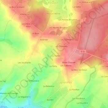
Name: Topografische Karte Lignerolles, Höhe, Relief.
Durchschnittliche Höhe: 275 m
Minimale Höhe: 212 m
Maximale Höhe: 315 m
Vielen Dank für die Unterstützung dieser Website ❤️
Spenden
Spenden
Andere topografische Karten
Klicken Sie auf eine Karte, um ihre Topografie, ihre Höhe und ihr Relief anzuzeigen.
La Sablonnière
France > Normandie > Orne > Tourouvre au Perche > La Sablonnière
Durchschnittliche Höhe: 257 m
Vielen Dank für die Unterstützung dieser Website ❤️
Spenden
Spenden