
Topografische Karte Pastovce
Interaktive Karte
Klicken Sie auf die Karte, um die Höhe anzuzeigen.
Über diese Karte
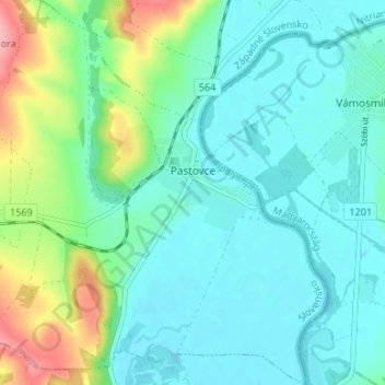
Name: Topografische Karte Pastovce, Höhe, Relief.
Durchschnittliche Höhe: 135 m
Minimale Höhe: 108 m
Maximale Höhe: 226 m
The village lies at an altitude of 124 metres and covers an area of 12.859 km². It has a population of about 540 people.
Andere topografische Karten
Klicken Sie auf eine Karte, um ihre Topografie, ihre Höhe und ihr Relief anzuzeigen.
Tlmače
Slovakia > Region of Nitra > District of Levice
Tlmače, District of Levice, Region of Nitra, Western Slovakia, 935 21, Slovakia
Durchschnittliche Höhe: 192 m
Veselá
Slovakia > Region of Nitra > District of Levice > Šarovce
Veselá, Šarovce, District of Levice, Region of Nitra, Western Slovakia, Slovakia
Durchschnittliche Höhe: 149 m
Šahy
Slovakia > Region of Nitra > District of Levice
Šahy, District of Levice, Region of Nitra, Western Slovakia, 936 01, Slovakia
Durchschnittliche Höhe: 179 m