
Spenden
Topografische Karte Milam Glacier
Klicken Sie auf die Karte, um die Höhe anzuzeigen.
Spenden
Milam Glacier
Milam Glacier, covering around 37 km2 (14 sq mi) area of 16 km (10 mi) length, is located about 15 kilometres (9 mi) northeast of Nanda Devi. It ranges in elevation from about 5,500 metres (18,000 ft) to about 3,870 metres (12,700 ft) at its snout. Situated on the south facing slope of the main Great Himalayas range, it originates from the eastern slope of Trishuli and the southern slope of its eastern subsidiary Kohli. The subsidiary glaciers coming off the peaks of Hardeol, Mangraon (6,568 m), Deo Damla (6,637 m), and Sakram (6,254 m) on the eastern rim of the Nanda Devi Sanctuary also flow into it from the west, while on the east it is fed by glaciers from Nanda Gond (6,315 m) and Nanda Pal (6,306 m).
Spenden
Über diese Karte
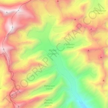
Name: Topografische Karte Milam Glacier, Höhe, Relief.
Durchschnittliche Höhe: 5.229 m
Minimale Höhe: 3.582 m
Maximale Höhe: 7.111 m
Spenden
Andere topografische Karten
Klicken Sie auf eine Karte, um ihre Topografie, ihre Höhe und ihr Relief anzuzeigen.