Geolokalisieren
👉 Easily get elevation data in JSON, GeoTIFF and KML formats using Elevation API
Vielen Dank für die Unterstützung dieser Website ❤️
Spenden

Topografische Karte Val Veny

Klicken Sie auf die Karte, um die Höhe anzuzeigen.

👉 Easily get elevation data in JSON, GeoTIFF and KML formats using Elevation API
Vielen Dank für die Unterstützung dieser Website ❤️
Spenden

Über diese Karte

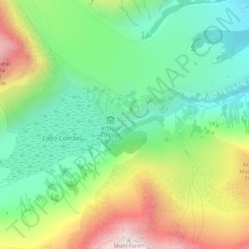
Name: Topografische Karte Val Veny, Höhe, Relief.

Ort: Val Veny, Courmayeur, Valle d'Aosta, Italia (45.76587 6.85992 45.78587 6.87992)

Durchschnittliche Höhe: 2.151 m

Minimale Höhe: 1.801 m

Maximale Höhe: 2.755 m

👉 Easily get elevation data in JSON, GeoTIFF and KML formats using Elevation API
Vielen Dank für die Unterstützung dieser Website ❤️
Spenden

Andere topografische Karten

Klicken Sie auf eine Karte, um ihre Topografie, ihre Höhe und ihr Relief anzuzeigen.

Ghiacciaio della Brenva

Italia > Valle d'Aosta > Courmayeur

Durchschnittliche Höhe: 3.373 m

Ghiacciaio del Miage

Italia > Valle d'Aosta > Courmayeur

Durchschnittliche Höhe: 2.912 m

Ghiacciaio di Pré de Bar

Italia > Valle d'Aosta > Courmayeur

Durchschnittliche Höhe: 3.078 m

Ghiacciaio di Bionassay

Italia > Valle d'Aosta > Courmayeur

Durchschnittliche Höhe: 3.356 m

Vielen Dank für die Unterstützung dieser Website ❤️
Spenden

Ghiacciaio della Lex Blanche

Italia > Valle d'Aosta > Courmayeur

Durchschnittliche Höhe: 3.132 m