
Topografische Karte The Dalles
Interaktive Karte
Klicken Sie auf die Karte, um die Höhe anzuzeigen.
Über diese Karte
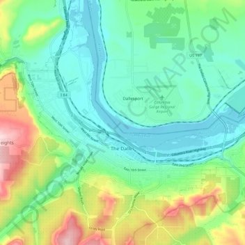
Name: Topografische Karte The Dalles, Höhe, Relief.
Ort: The Dalles, Wasco County, Oregon, United States (45.58517 -121.22910 45.64030 -121.12104)
Durchschnittliche Höhe: 105 m
Minimale Höhe: 18 m
Maximale Höhe: 343 m
As in the summer, winter temperatures can vary tremendously from one day to the next. During arctic air events the daytime high temperatures will generally be well below 32 °F or 0 °C, while a strong subtropical push can raise temperatures into the 50s and low 60s F, even in January. It is quite common for relatively cold air to become trapped at low elevations due to an inversion above; depending on the temperature of the surface airmass, depth of the inversion layer, and temperatures above the inversion layer, this can result in snow, sleet, freezing rain or a very cold liquid rain.
Andere topografische Karten
Klicken Sie auf eine Karte, um ihre Topografie, ihre Höhe und ihr Relief anzuzeigen.
Pine Grove
United States > Oregon > Wasco County
Pine Grove, Wasco County, Oregon, United States
Durchschnittliche Höhe: 713 m
Dant
United States > Oregon > Wasco County
Dant, Wasco County, Oregon, United States
Durchschnittliche Höhe: 536 m
Mosier
United States > Oregon > Wasco County
Mosier, Wasco County, Oregon, United States
Durchschnittliche Höhe: 74 m
Tygh Valley
United States > Oregon > Wasco County > Tygh Valley
Tygh Valley, Wasco County, Oregon, United States
Durchschnittliche Höhe: 397 m
Maupin
United States > Oregon > Wasco County
Maupin, Wasco County, Oregon, United States
Durchschnittliche Höhe: 368 m
Shaniko
United States > Oregon > Wasco County > Shaniko
Shaniko, Wasco County, Oregon, United States
Durchschnittliche Höhe: 1.009 m
Frog Lake
United States > Oregon > Wasco County
Frog Lake, Wasco County, Oregon, United States
Durchschnittliche Höhe: 1.266 m