
Topografische Karte Σμόλικας
Interaktive Karte
Klicken Sie auf die Karte, um die Höhe anzuzeigen.
Über diese Karte
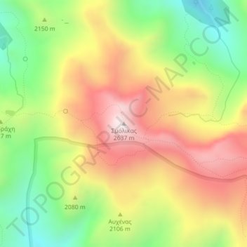
Name: Topografische Karte Σμόλικας, Höhe, Relief.
Durchschnittliche Höhe: 2.199 m
Minimale Höhe: 1.808 m
Maximale Höhe: 2.607 m
Mount Smolikas (Greek: Σμόλικας; Aromanian: Smolcu) is a mountain in the Ioannina regional unit, northwestern Greece. At a height of 2,637 metres above sea level, it is the highest of the Pindus Mountains, and the second highest mountain in Greece after Mount Olympus. The mountain consists of ophiolite rocks. During several periods in the Pleistocene the northern and eastern cirques and valleys were glaciated. The last glaciers of this area retreated around 11,500 years ago. It is drained by the river Vjosa to the south, and the river Vourkopotamo (a tributary of the Sarantaporos) to the north. There is a small alpine lake called "Drakolimni Smolika" near the summit, at about 2,200 metres elevation. Nearby mountain ranges are Tymfi to the south, Gramos to the northwest, Vasilitsa to the southeast and Voio to the northeast.
Andere topografische Karten
Klicken Sie auf eine Karte, um ihre Topografie, ihre Höhe und ihr Relief anzuzeigen.
Ioannina
Greece > Epirus and Western Macedonia > Ioannina Regional Unit
Ioannina, Ioannina Municipality, Ioannina Regional Unit, Epirus, Epirus and Western Macedonia, Greece
Durchschnittliche Höhe: 493 m
Μικρό Πάπιγκο
Greece > Epirus and Western Macedonia > Ioannina Regional Unit
Μικρό Πάπιγκο, Zagori Municipality, Ioannina Regional Unit, Epirus, Epirus and Western Macedonia, 440 04, Greece
Durchschnittliche Höhe: 1.237 m
Ioannina
Greece > Epirus and Western Macedonia > Ioannina Regional Unit
Ioannina, Δημοτική Ενότητα Ιωαννιτών, Ioannina Municipality, Ioannina Regional Unit, Epirus, Epirus and Western Macedonia, 453 33, Greece
Durchschnittliche Höhe: 724 m
Παρακάλαμος
Greece > Epirus and Western Macedonia > Ioannina Regional Unit
Παρακάλαμος, Pogoni Municipality, Ioannina Regional Unit, Epirus, Epirus and Western Macedonia, 440 04, Greece
Durchschnittliche Höhe: 416 m
Kalpaki
Greece > Epirus and Western Macedonia > Ioannina Regional Unit
Kalpaki, Dodoni Municipality, Ioannina Regional Unit, Epirus, Epirus and Western Macedonia, Greece
Durchschnittliche Höhe: 1.068 m
Καστανιά
Greece > Epirus and Western Macedonia > Ioannina Regional Unit
Καστανιά, Konitsa Municipality, Ioannina Regional Unit, Epirus, Epirus and Western Macedonia, 440 15, Greece
Durchschnittliche Höhe: 1.069 m
Μέτσοβο
Greece > Epirus and Western Macedonia > Ioannina Regional Unit
Μέτσοβο, Metsovo Municipality, Ioannina Regional Unit, Epirus, Epirus and Western Macedonia, 442 00, Greece
Durchschnittliche Höhe: 1.318 m
Βραδέτο
Greece > Epirus and Western Macedonia > Ioannina Regional Unit > Καπέσοβο > Βραδέτο
Βραδέτο, Καπέσοβο, Zagori Municipality, Ioannina Regional Unit, Epirus, Epirus and Western Macedonia, 44018, Greece
Durchschnittliche Höhe: 1.174 m
Perama
Greece > Epirus and Western Macedonia > Ioannina Regional Unit > Perama Municipal Unit
Perama, Perama Municipal Unit, Ioannina Municipality, Ioannina Regional Unit, Epirus, Epirus and Western Macedonia, 455 00, Greece
Durchschnittliche Höhe: 653 m