
Topografische Karte Clarens
Interaktive Karte
Klicken Sie auf die Karte, um die Höhe anzuzeigen.
Über diese Karte
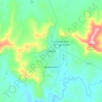
Name: Topografische Karte Clarens, Höhe, Relief.
Durchschnittliche Höhe: 1.874 m
Minimale Höhe: 1.693 m
Maximale Höhe: 2.428 m
Andere topografische Karten
Klicken Sie auf eine Karte, um ihre Topografie, ihre Höhe und ihr Relief anzuzeigen.
Sand River
South Africa > Free State > Thabo Mofutsanyana District Municipality > Dihlabeng Local Municipality
Sand River, Dihlabeng Local Municipality, Thabo Mofutsanyana District Municipality, Free State, South Africa
Durchschnittliche Höhe: 1.615 m
Bethlehem
South Africa > Free State > Thabo Mofutsanyana District Municipality > Dihlabeng Local Municipality
Bethlehem, Dihlabeng Local Municipality, Thabo Mofutsanyana District Municipality, Free State, 9700, South Africa
Durchschnittliche Höhe: 1.675 m
Botterkloof Dam
South Africa > Free State > Thabo Mofutsanyana District Municipality > Dihlabeng Local Municipality
Botterkloof Dam, Dihlabeng Ward 11, Dihlabeng Local Municipality, Thabo Mofutsanyana District Municipality, Free State, South Africa
Durchschnittliche Höhe: 1.760 m
Fouriesburg
South Africa > Free State > Thabo Mofutsanyana District Municipality > Dihlabeng Local Municipality
Fouriesburg, Dihlabeng Local Municipality, Thabo Mofutsanyana District Municipality, Free State, South Africa
Durchschnittliche Höhe: 1.745 m