
Spenden
Topografische Karte Farrington Gurney
Klicken Sie auf die Karte, um die Höhe anzuzeigen.
Spenden
Über diese Karte
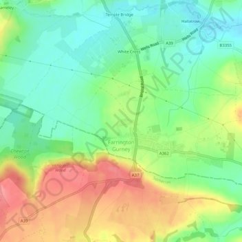
Name: Topografische Karte Farrington Gurney, Höhe, Relief.
Durchschnittliche Höhe: 118 m
Minimale Höhe: 82 m
Maximale Höhe: 169 m
Spenden
Andere topografische Karten
Klicken Sie auf eine Karte, um ihre Topografie, ihre Höhe und ihr Relief anzuzeigen.
Hallatrow
United Kingdom > England > Bath and North East Somerset > High Littleton
Durchschnittliche Höhe: 119 m
Old Mills
United Kingdom > England > Bath and North East Somerset > Paulton
Durchschnittliche Höhe: 126 m
Norton Hawkfield
United Kingdom > England > Bath and North East Somerset > Norton Malreward
Durchschnittliche Höhe: 96 m
Amesbury
United Kingdom > England > Bath and North East Somerset > Timsbury
Durchschnittliche Höhe: 130 m
Spenden
Knowle Hill
United Kingdom > England > Bath and North East Somerset > Chew Magna
Durchschnittliche Höhe: 65 m
Little Solsbury Hill
United Kingdom > England > Bath and North East Somerset > Batheaston
Durchschnittliche Höhe: 88 m
Bathwick Hill
United Kingdom > England > Bath and North East Somerset > Bath
Number 1 (Bathwick Lodge) is a 2-storey villa with a steep Mansard room, built in 1825, extended in 1840 and the late C19. Probably by John Pinch the Elder.[4] Number 2 is from the early 19th century and has shutters over the windows.[11] Number 3 includes a porch which is elaborately enriched with carving,…
Durchschnittliche Höhe: 93 m
North Wick
United Kingdom > England > Bath and North East Somerset > Chew Magna
Durchschnittliche Höhe: 110 m
Spenden
Carlingcott
United Kingdom > England > Bath and North East Somerset > Peasedown St. John
Durchschnittliche Höhe: 123 m
Tadwick
United Kingdom > England > Bath and North East Somerset > Swainswick
Durchschnittliche Höhe: 161 m
Pipehouse
United Kingdom > England > Bath and North East Somerset > Hinton Charterhouse
Durchschnittliche Höhe: 94 m
Spenden
Sydney Gardens
United Kingdom > England > Bath and North East Somerset > Bath
Durchschnittliche Höhe: 75 m
Keynsham Memorial Park
United Kingdom > England > Bath and North East Somerset > Keynsham
Durchschnittliche Höhe: 29 m
Stoney Littleton
United Kingdom > England > Bath and North East Somerset > Shoscombe
Durchschnittliche Höhe: 116 m
Spenden
Clutton Hill
United Kingdom > England > Bath and North East Somerset > Farmborough
Durchschnittliche Höhe: 133 m
Spenden
Cholwell
United Kingdom > England > Bath and North East Somerset > Clutton
Durchschnittliche Höhe: 130 m
Sharpstone
United Kingdom > England > Bath and North East Somerset > Freshford
Durchschnittliche Höhe: 93 m
Park Corner
United Kingdom > England > Bath and North East Somerset > Freshford > Park Corner
Durchschnittliche Höhe: 93 m
Spenden
Maes Knoll
United Kingdom > England > Bath and North East Somerset > Norton Malreward
Durchschnittliche Höhe: 110 m
Sydney Gardens
United Kingdom > England > Bath and North East Somerset > Bath
Durchschnittliche Höhe: 77 m
Wick Green
United Kingdom > England > Bath and North East Somerset > Bishop Sutton
Durchschnittliche Höhe: 82 m
Whitley Batts
United Kingdom > England > Bath and North East Somerset > Pensford
Durchschnittliche Höhe: 87 m
Spenden
Chewton Keynsham
United Kingdom > England > Bath and North East Somerset > Compton Dando
Durchschnittliche Höhe: 57 m
Mearns
United Kingdom > England > Bath and North East Somerset > Farmborough
Durchschnittliche Höhe: 129 m
Clandown
United Kingdom > England > Bath and North East Somerset > Radstock
Durchschnittliche Höhe: 118 m
Spenden