
Vielen Dank für die Unterstützung dieser Website ❤️
Spenden
Spenden
Topografische Karte Kalluvathukkal
Klicken Sie auf die Karte, um die Höhe anzuzeigen.
Vielen Dank für die Unterstützung dieser Website ❤️
Spenden
Spenden
Über diese Karte
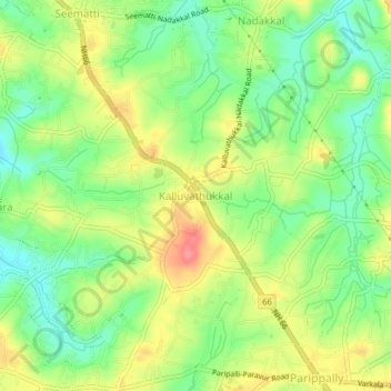
Name: Topografische Karte Kalluvathukkal, Höhe, Relief.
Ort: Kalluvathukkal, Kollam, Kerala, 691578, India (8.81125 76.72586 8.85125 76.76586)
Durchschnittliche Höhe: 40 m
Minimale Höhe: 5 m
Maximale Höhe: 82 m
Vielen Dank für die Unterstützung dieser Website ❤️
Spenden
Spenden
Andere topografische Karten
Klicken Sie auf eine Karte, um ihre Topografie, ihre Höhe und ihr Relief anzuzeigen.
Ashtamudi Lake
India > Kerala > Kollam > Kottayathukadavu
Ashtamudi Lake (Ashtamudi Kayal), in the Kollam District of the Indian state of Kerala, is the most visited backwater and lake in the state. It possesses a unique wetland ecosystem and a large palm-shaped (also described as octopus-shaped) water body, second only in size to the Vembanad estuary ecosystem of…
Durchschnittliche Höhe: 6 m
Vielen Dank für die Unterstützung dieser Website ❤️
Spenden
Spenden