
Vielen Dank für die Unterstützung dieser Website ❤️
Spenden
Spenden
Topografische Karte Chodzież
Klicken Sie auf die Karte, um die Höhe anzuzeigen.
Vielen Dank für die Unterstützung dieser Website ❤️
Spenden
Spenden
Chodzież
Five kilometers west of Chodzież, at the edge of the Chodzieskie lakelands, Mt. Gontyniec rises 192 meters above sea level as the highest peak in a chain of moraine hills; at the same time it has the highest elevation in northern Poland. Deep valleys and ridges covered with a 100-year-old beech forest ensure diversified surroundings.
Vielen Dank für die Unterstützung dieser Website ❤️
Spenden
Spenden
Über diese Karte
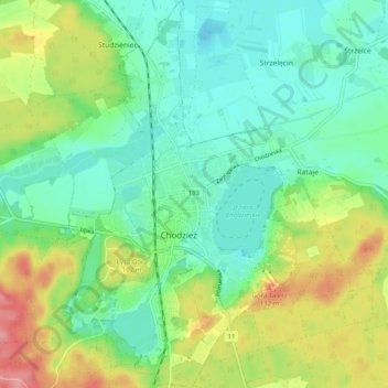
Name: Topografische Karte Chodzież, Höhe, Relief.
Durchschnittliche Höhe: 78 m
Minimale Höhe: 44 m
Maximale Höhe: 147 m
Vielen Dank für die Unterstützung dieser Website ❤️
Spenden
Spenden