
Topografische Karte Emerson
Interaktive Karte
Klicken Sie auf die Karte, um die Höhe anzuzeigen.
Über diese Karte
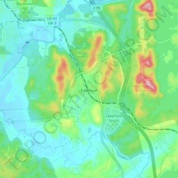
Name: Topografische Karte Emerson, Höhe, Relief.
Ort: Emerson, Bartow County, Georgia, 30137, United States (34.09402 -84.78494 34.16097 -84.71986)
Durchschnittliche Höhe: 254 m
Minimale Höhe: 205 m
Maximale Höhe: 402 m
Andere topografische Karten
Klicken Sie auf eine Karte, um ihre Topografie, ihre Höhe und ihr Relief anzuzeigen.
Rydal
United States > Georgia > Bartow County > Rydal
Rydal, Bartow County, Georgia, 30139:30171:30184, United States
Durchschnittliche Höhe: 273 m
White
United States > Georgia > Bartow County > White
White, Bartow County, Georgia, United States
Durchschnittliche Höhe: 271 m
Cartersville
United States > Georgia > Bartow County
Cartersville, Bartow County, Georgia, 30120, United States
Durchschnittliche Höhe: 260 m