Geolokalisieren

Topografische Karte Kullu

Interaktive Karte

Klicken Sie auf die Karte, um die Höhe anzuzeigen.

Über diese Karte

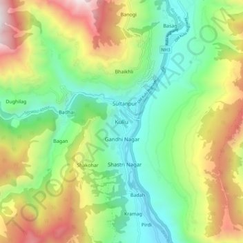
Name: Topografische Karte Kullu, Höhe, Relief.

Ort: Kullu, Himachal Pradesh, 175100, India (31.91790 77.06892 31.99790 77.14892)

Durchschnittliche Höhe: 1.808 m

Minimale Höhe: 1.130 m

Maximale Höhe: 2.972 m

Kullu town has an average elevation of 1,278 m (4,193 ft). It lies on the bank of Beas River. A major tributary, Sarvari, (derived from "Shiv-Baardi") leads to the less explored and steeper Lug-valley on the west. On the east of Kullu lies a broad mountainous ridge having the village-temples of Bijli Mahadev, Mounty Nag and Pueed. Beyond the ridge lies Manikaran valley, along the Paarvati river which joins Beas at Sangam in Bhuntar. On the south of Kullu lie the town of Bhuntar, Out (leading to Anni, Banjar and Siraj Valley) and Mandi (in Mandi district). Historically Kullu was accessible from Shimla via Siraj valley or through passes on the west leading to Jogindernagar and onto Kangra. To the north lies the town of Manali, which through the Rohtang pass leads onto the Lahaul and Spiti Valley. One can see an enormous change in the climate as one climbs up the windward side of the ranges to proceed to the leeward and much drier plateaus to the north of Manali.