
Topografische Karte Tieton
Interaktive Karte
Klicken Sie auf die Karte, um die Höhe anzuzeigen.
Über diese Karte
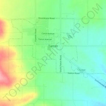
Name: Topografische Karte Tieton, Höhe, Relief.
Ort: Tieton, Yakima County, Washington, 98947, United States (46.69081 -120.77257 46.70955 -120.73126)
Durchschnittliche Höhe: 594 m
Minimale Höhe: 553 m
Maximale Höhe: 669 m
Andere topografische Karten
Klicken Sie auf eine Karte, um ihre Topografie, ihre Höhe und ihr Relief anzuzeigen.
Naches Heights
United States > Washington > Yakima County
Naches Heights, Yakima County, Washington, United States
Durchschnittliche Höhe: 501 m
Ahtanum State Forest
United States > Washington > Yakima County
Ahtanum State Forest, Yakima County, Washington, United States
Durchschnittliche Höhe: 1.214 m
Zillah
United States > Washington > Yakima County
Zillah, Yakima County, Washington, 98953, United States
Durchschnittliche Höhe: 260 m
Selah
United States > Washington > Yakima County > Selah
Selah, Yakima County, Washington, 98942, United States
Durchschnittliche Höhe: 395 m