
Topografische Karte Paskenta
Interaktive Karte
Klicken Sie auf die Karte, um die Höhe anzuzeigen.
Über diese Karte
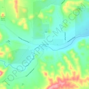
Name: Topografische Karte Paskenta, Höhe, Relief.
Ort: Paskenta, Tehama County, California, 96074, United States (39.86429 -122.56697 39.90429 -122.52697)
Durchschnittliche Höhe: 268 m
Minimale Höhe: 213 m
Maximale Höhe: 389 m
Paskenta (Wintun: Paskenti) is a small unincorporated town in Tehama County, California. Historically, it had greater local importance due to the presence of an active lumber mill. The ZIP Code is 96074. The community is inside area code 530 and the Paskenta CDP. Paskenta sits at an elevation of 725 feet (221 m). The 2010 United States census reported Paskenta's population was 112. Paskenta was originally inhabited by a tribe of Nomlaki people who are now part of the federally-recognized Paskenta Band of Nomlaki Indians.
Andere topografische Karten
Klicken Sie auf eine Karte, um ihre Topografie, ihre Höhe und ihr Relief anzuzeigen.
Manton
United States > California > Tehama County
Manton, Tehama County, California, United States
Durchschnittliche Höhe: 722 m
Red Bluff
United States > California > Tehama County
Red Bluff, Tehama County, California, 96080, United States
Durchschnittliche Höhe: 103 m
Manton
United States > California > Tehama County
Manton, Tehama County, California, United States
Durchschnittliche Höhe: 722 m
Mineral
United States > California > Tehama County
Mineral, Tehama County, California, United States
Durchschnittliche Höhe: 1.752 m
Rancho Tehama Reserve
United States > California > Tehama County
Rancho Tehama Reserve, Tehama County, CAL Fire Northern Region, California, United States
Durchschnittliche Höhe: 237 m
Corning
United States > California > Tehama County
Corning, Tehama County, CAL Fire Northern Region, California, 96021, United States
Durchschnittliche Höhe: 86 m
Paynes Creek
United States > California > Tehama County
Paynes Creek, Tehama County, California, United States
Durchschnittliche Höhe: 143 m
Paynes Creek
United States > California > Tehama County > Dales
Paynes Creek, Dales, Tehama County, CAL Fire Northern Region, California, United States
Durchschnittliche Höhe: 222 m
Los Molinos
United States > California > Tehama County > Los Molinos
Los Molinos, Tehama County, California, 96055, United States
Durchschnittliche Höhe: 76 m