
Spenden
Topografische Karte SIA
Klicken Sie auf die Karte, um die Höhe anzuzeigen.
Spenden
Über diese Karte
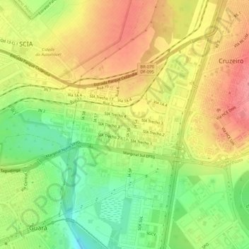
Name: Topografische Karte SIA, Höhe, Relief.
Durchschnittliche Höhe: 1.108 m
Minimale Höhe: 1.062 m
Maximale Höhe: 1.148 m
Spenden
Andere topografische Karten
Klicken Sie auf eine Karte, um ihre Topografie, ihre Höhe und ihr Relief anzuzeigen.
Brasília
Brazil > Federal District > Região Integrada de Desenvolvimento do Distrito Federal e Entorno
The city sits at an elevation of 1,000 metres (3,300 ft) and more, high on the Brazilian Highlands in the country's center-western region. Paranoá Lake, a large artificial lake, was built to increase the amount of water available and to maintain the region's humidity. It has a marina, and hosts wakeboarders…
Durchschnittliche Höhe: 1.084 m
Condominio Verde Perto
Brazil > Federal District > Região Integrada de Desenvolvimento do Distrito Federal e Entorno > Guará
Durchschnittliche Höhe: 1.099 m