
Topografische Karte Rose Island
Interaktive Karte
Klicken Sie auf die Karte, um die Höhe anzuzeigen.
Über diese Karte
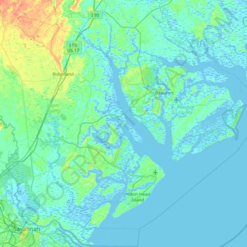
Name: Topografische Karte Rose Island, Höhe, Relief.
Durchschnittliche Höhe: 5 m
Minimale Höhe: -6 m
Maximale Höhe: 41 m
Andere topografische Karten
Klicken Sie auf eine Karte, um ihre Topografie, ihre Höhe und ihr Relief anzuzeigen.
Parris Island
United States > South Carolina > Beaufort County > Port Royal
Parris Island, Port Royal, Beaufort County, South Carolina, 29905, United States
Durchschnittliche Höhe: 3 m
Port Royal Landing
United States > South Carolina > Beaufort County > Port Royal > Port Royal Landing
Port Royal Landing, Port Royal, Beaufort County, South Carolina, 29935, United States
Durchschnittliche Höhe: 5 m
Green Pond
United States > South Carolina > Beaufort County > Port Royal > Green Pond
Green Pond, Port Royal, Beaufort County, South Carolina, United States
Durchschnittliche Höhe: 4 m