
Topografische Karte Kesley
Interaktive Karte
Klicken Sie auf die Karte, um die Höhe anzuzeigen.
Über diese Karte
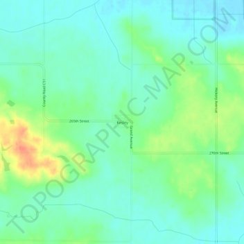
Name: Topografische Karte Kesley, Höhe, Relief.
Ort: Kesley, Butler County, Iowa, 50649, United States (42.64226 -92.92976 42.68226 -92.88976)
Durchschnittliche Höhe: 305 m
Minimale Höhe: 290 m
Maximale Höhe: 339 m
Andere topografische Karten
Klicken Sie auf eine Karte, um ihre Topografie, ihre Höhe und ihr Relief anzuzeigen.
Parkersburg
United States > Iowa > Butler County
Parkersburg, Butler County, Iowa, United States
Durchschnittliche Höhe: 295 m
Austinville
United States > Iowa > Butler County
Austinville, Butler County, Iowa, 50608, United States
Durchschnittliche Höhe: 312 m
Greene
United States > Iowa > Butler County
Greene, Butler County, Iowa, United States
Durchschnittliche Höhe: 301 m
Shell Rock
United States > Iowa > Butler County
Shell Rock, Butler County, Iowa, United States
Durchschnittliche Höhe: 279 m
Aplington
United States > Iowa > Butler County
Aplington, Butler County, Iowa, United States
Durchschnittliche Höhe: 302 m
Aredale
United States > Iowa > Butler County
Aredale, Butler County, Iowa, United States
Durchschnittliche Höhe: 315 m
Allison
United States > Iowa > Butler County
Allison, Butler County, Iowa, United States
Durchschnittliche Höhe: 317 m
Clarksville
United States > Iowa > Butler County
Clarksville, Butler County, Iowa, United States
Durchschnittliche Höhe: 285 m
Dumont
United States > Iowa > Butler County
Dumont, Butler County, Iowa, United States
Durchschnittliche Höhe: 301 m
New Hartford
United States > Iowa > Butler County
New Hartford, Butler County, Iowa, United States
Durchschnittliche Höhe: 276 m
Bristow
United States > Iowa > Butler County
Bristow, Butler County, Iowa, United States
Durchschnittliche Höhe: 312 m