
Topografische Karte François Lake
Interaktive Karte
Klicken Sie auf die Karte, um die Höhe anzuzeigen.
Über diese Karte
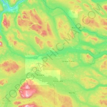
Name: Topografische Karte François Lake, Höhe, Relief.
Durchschnittliche Höhe: 984 m
Minimale Höhe: 564 m
Maximale Höhe: 2.251 m
Andere topografische Karten
Klicken Sie auf eine Karte, um ihre Topografie, ihre Höhe und ihr Relief anzuzeigen.
Picket Hill
Canada > British Columbia > Regional District of Bulkley-Nechako > Area E (Ootsa Lake/François Lake)
Picket Hill, Area E (Ootsa Lake/François Lake), Regional District of Bulkley-Nechako, British Columbia, Canada
Durchschnittliche Höhe: 924 m
Johns Island
Canada > British Columbia > Regional District of Bulkley-Nechako > Area E (Ootsa Lake/François Lake)
Johns Island, Area E (Ootsa Lake/François Lake), Regional District of Bulkley-Nechako, British Columbia, Canada
Durchschnittliche Höhe: 965 m