
Topografische Karte Tuba
Klicken Sie auf die Karte, um die Höhe anzuzeigen.
Tuba
Tuba's topography is generally characterized by irregular rugged terrain and steep slopes with several mountain peaks rising from the table land itself. Mount Santo Tomas, the highest peak in the municipality soars to 2,252 metres (7,388 ft) above sea level.
Über diese Karte
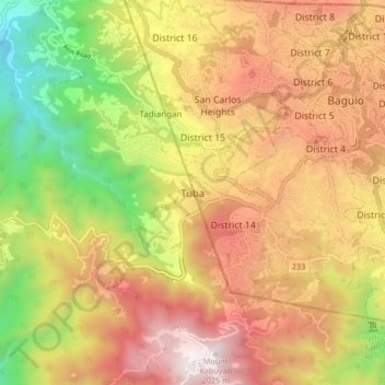
Name: Topografische Karte Tuba, Höhe, Relief.
Durchschnittliche Höhe: 1.242 m
Minimale Höhe: 357 m
Maximale Höhe: 2.028 m
Andere topografische Karten
Klicken Sie auf eine Karte, um ihre Topografie, ihre Höhe und ihr Relief anzuzeigen.
La Trinidad
The terrain is generally mountainous with springs, rivers and creeks. The town has a valley which encompasses several barangays. The valley floor elevation is at 1,300 metres (4,300 ft) above sea level. Elevation ranges from 500 to 1,700 metres (1,600 to 5,600 ft) above sea level.
Durchschnittliche Höhe: 1.123 m
Wangal, La Trinidad, Benguet
Philippines > Benguet > La Trinidad > Ampasit
Durchschnittliche Höhe: 1.352 m
La Trinidad
The terrain is generally mountainous with springs, rivers and creeks. The town has a valley which encompasses several barangays. The valley floor elevation is at 1,300 metres (4,300 ft) above sea level. Elevation ranges from 500 to 1,700 metres (1,600 to 5,600 ft) above sea level.
Durchschnittliche Höhe: 1.123 m
Ambuklao Dam
Philippines > Benguet > Ambuclao > Ambangol
SNAP-Benguet began a massive rehabilitation project that restored Ambuklao to operating status and increased its capacity from 75 MW to 105 MW. The project required the construction of a new intake, headrace and penstock, elevation of tailrace tunnel outlet, de-silting of tailrace tunnel and replacement of…
Durchschnittliche Höhe: 808 m
La Trinidad
The terrain is generally mountainous with springs, rivers and creeks. The town has a valley which encompasses several barangays. The valley floor elevation is at 1,300 metres (4,300 ft) above sea level. Elevation ranges from 500 to 1,700 metres (1,600 to 5,600 ft) above sea level.
Durchschnittliche Höhe: 1.130 m
Bolo Creek
Philippines > Benguet > La Trinidad > Cruz > Central Buyagan
Durchschnittliche Höhe: 1.321 m