Geolokalisieren
👉 Easily get elevation data in JSON, GeoTIFF and KML formats using Elevation API
Vielen Dank für die Unterstützung dieser Website ❤️
Spenden

Topografische Karte Bas-Saint-Laurent

Klicken Sie auf die Karte, um die Höhe anzuzeigen.

👉 Easily get elevation data in JSON, GeoTIFF and KML formats using Elevation API
Vielen Dank für die Unterstützung dieser Website ❤️
Spenden

Bas-Saint-Laurent

The topography of Bas-Saint-Laurent has two main elements : the plateaus of the Appalachian Mountains, called Notre Dame Mountains, and the lowlands in the fine stripe of land along the Saint Lawrence river. These are separated by an intermediate area of ridges and foothills which meld with the plateaus. The Notre Dame Mountains, are a group of small mountains with summits reaching between 600 and 700 m (2,000 and 2,300 ft) high. the landscape is sometimes interrupted by valleys, like the Témiscouata valley or Matapedia Valley. These two parallel valleys allow access to The Maritimes, Maine and Chaleur Bay.

👉 Easily get elevation data in JSON, GeoTIFF and KML formats using Elevation API
Vielen Dank für die Unterstützung dieser Website ❤️
Spenden

Über diese Karte

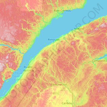
Name: Topografische Karte Bas-Saint-Laurent, Höhe, Relief.

Ort: Bas-Saint-Laurent, Quebec, Canada (47.06672 -70.20334 49.18906 -65.94841)

Durchschnittliche Höhe: 285 m

Minimale Höhe: -1 m

Maximale Höhe: 1.053 m

👉 Easily get elevation data in JSON, GeoTIFF and KML formats using Elevation API
Vielen Dank für die Unterstützung dieser Website ❤️
Spenden

Andere topografische Karten

Klicken Sie auf eine Karte, um ihre Topografie, ihre Höhe und ihr Relief anzuzeigen.

Mount Royal

Canada > Quebec > Urban agglomeration of Montreal > Montreal

The hill is part of the Monteregian Hills situated between the Laurentians and the Appalachian Mountains. It gave its Latin name, Mons Regius, to the Monteregian chain. The hill consists of three peaks: Colline de la Croix (or Mont Royal proper) at 233 m (764 ft), Colline d'Outremont (or Mount Murray, in the…

Durchschnittliche Höhe: 111 m

Lac Grand

Canada > Quebec > La Côte-de-Beaupré > Lac-Jacques-Cartier

Durchschnittliche Höhe: 565 m

Lac Saint-Henri

Canada > Quebec > La Jacques-Cartier > Lac-Croche

Durchschnittliche Höhe: 448 m

Mount Royal Park

Canada > Quebec > Urban agglomeration of Montreal > Montreal

The mountain is part of the Monteregian Hills situated between the Laurentians and the Appalachian Mountains. It gave its Latin name, Mons Regius, to the Monteregian chain. The mountain consists of three peaks: Colline de la Croix (or Mont Royal proper) at 233 m (764 ft), Colline d'Outremont (or Mount Murray,…

Durchschnittliche Höhe: 110 m

Vielen Dank für die Unterstützung dieser Website ❤️
Spenden

Lac Clair

Canada > Quebec > Matawinie > Rawdon

Durchschnittliche Höhe: 326 m

Île de l'Est

Canada > Quebec > Eeyou Istchee

Durchschnittliche Höhe: 377 m

Knowlton

Canada > Quebec > Brome-Missisquoi > Lac-Brome

Durchschnittliche Höhe: 234 m

Lac Levesque

Canada > Quebec > Les Laurentides > Lac-Supérieur

Durchschnittliche Höhe: 364 m

Vielen Dank für die Unterstützung dieser Website ❤️
Spenden

Mashteuiatsh

Canada > Quebec

Durchschnittliche Höhe: 106 m

Lac Caya

Canada > Quebec > La Vallée-de-la-Gatineau > Bouchette

Durchschnittliche Höhe: 199 m

Montmorency Falls

Canada > Quebec > La Côte-de-Beaupré > Boischatel

Durchschnittliche Höhe: 74 m

Vielen Dank für die Unterstützung dieser Website ❤️
Spenden

Johnson's Point

Canada > Quebec > Les Laurentides > Ivry-sur-le-Lac

Durchschnittliche Höhe: 443 m

Inlet

Canada > Quebec > Papineau > Mulgrave-et-Derry

Durchschnittliche Höhe: 243 m

Quebec

Canada > Quebec > Urban agglomeration of Québec

Quebec City was built on the north bank of the Saint Lawrence River, where it narrows and meets the mouth of the Saint-Charles River. Old Quebec is located on top and at the foot of Cap-Diamant, which is on the eastern edge of a plateau called the promontory of Quebec (Quebec hill). Because of this topographic…

Durchschnittliche Höhe: 100 m

Lac Tampon

Canada > Quebec > Le Fjord-du-Saguenay > Mont-Valin

Durchschnittliche Höhe: 810 m

Vielen Dank für die Unterstützung dieser Website ❤️
Spenden

West Brome

Canada > Quebec > Brome-Missisquoi > Lac-Brome

Durchschnittliche Höhe: 162 m

Lac Rémigny

Canada > Quebec > Rouyn-Noranda

Durchschnittliche Höhe: 277 m

Lac Shipagan

Canada > Quebec > Urban agglomeration of La Tuque > La Tuque

Durchschnittliche Höhe: 450 m

Lac Maria

Canada > Quebec > La Côte-de-Beaupré > Lac-Jacques-Cartier

Durchschnittliche Höhe: 755 m

Vielen Dank für die Unterstützung dieser Website ❤️
Spenden

Black and White

Canada > Quebec > Les Laurentides > Montcalm

Durchschnittliche Höhe: 297 m

Mont Condor Ouest

Canada > Quebec > Les Laurentides > Val-David

Durchschnittliche Höhe: 373 m

Languedoc

Canada > Quebec > Abitibi-Ouest > Rivière-Ojima

Durchschnittliche Höhe: 308 m

Mystic

Canada > Quebec > Brome-Missisquoi > Saint-Ignace-de-Stanbridge

Durchschnittliche Höhe: 60 m

Vielen Dank für die Unterstützung dieser Website ❤️
Spenden

Mont Brome

Canada > Quebec > Brome-Missisquoi > Bromont

Durchschnittliche Höhe: 331 m

Cap Tourmente

Canada > Quebec > La Côte-de-Beaupré > Sault-au-Cochon

Durchschnittliche Höhe: 295 m

Lac Emro

Canada > Quebec > Pontiac > Lac-Nilgaut

Durchschnittliche Höhe: 311 m

Vielen Dank für die Unterstützung dieser Website ❤️
Spenden

Matamec

Canada > Quebec > Sept-Rivières > Sept-Îles

Durchschnittliche Höhe: 19 m

Cap Diamant

Canada > Quebec > Quebec City

Durchschnittliche Höhe: 28 m

Lac Suffolk

Canada > Quebec > Papineau > Boileau

Durchschnittliche Höhe: 269 m

Pingualuit Crater

Canada > Quebec > Kativik > Rivière-Koksoak

Durchschnittliche Höhe: 538 m

Vielen Dank für die Unterstützung dieser Website ❤️
Spenden

Le Massif

Canada > Quebec > Charlevoix > Petite-Rivière-Saint-François

Durchschnittliche Höhe: 729 m

Big Black River

Canada > Quebec > L'Islet (MRC) > Saint-Marcel

Durchschnittliche Höhe: 384 m

Lost River

Canada > Quebec > Harrington > Lost River

Durchschnittliche Höhe: 276 m

Vielen Dank für die Unterstützung dieser Website ❤️
Spenden

Moore Creek

Canada > Quebec > Pontiac (MRC) > Otter Lake

Durchschnittliche Höhe: 253 m

Saint Lawrence River

Canada > Quebec > L'Islet

Durchschnittliche Höhe: 276 m

Laurentian Mountains

Canada > Quebec > Rivière-à-Pierre

Durchschnittliche Höhe: 325 m

Acton Vale

Canada > Quebec > Acton > Acton Vale

Durchschnittliche Höhe: 95 m

Vielen Dank für die Unterstützung dieser Website ❤️
Spenden

Barachois

Canada > Quebec > Le Rocher-Percé > Percé > Barachois

Durchschnittliche Höhe: 32 m

Lac Chuchua

Canada > Quebec > Papineau > Duhamel

Durchschnittliche Höhe: 298 m

Vielen Dank für die Unterstützung dieser Website ❤️
Spenden

Mont Singer

Canada > Quebec > Memphrémagog > Potton

Durchschnittliche Höhe: 603 m

Mont Éléphant

Canada > Quebec > Les Laurentides > Lac-Supérieur

Durchschnittliche Höhe: 365 m

Mont Éléphant

Canada > Quebec > Memphrémagog > Potton

Durchschnittliche Höhe: 389 m

Mont Hawk

Canada > Quebec > Memphrémagog > Potton

Durchschnittliche Höhe: 345 m

Vielen Dank für die Unterstützung dieser Website ❤️
Spenden

Lac Lise

Canada > Quebec > Maskinongé (MRC) > Saint-Alexis-des-Monts

Durchschnittliche Höhe: 389 m

Lac du Chevreuil

Canada > Quebec > La Vallée-de-la-Gatineau > Denholm

Durchschnittliche Höhe: 394 m

Lakefield

Canada > Quebec > Argenteuil > Gore

Durchschnittliche Höhe: 263 m

Vielen Dank für die Unterstützung dieser Website ❤️
Spenden

Lac Dumont

Canada > Quebec > Charlevoix-Est > Baie-Sainte-Catherine

Durchschnittliche Höhe: 152 m