
Topografische Karte Spraberry
Interaktive Karte
Klicken Sie auf die Karte, um die Höhe anzuzeigen.
Über diese Karte
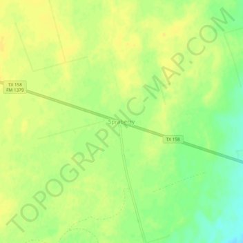
Name: Topografische Karte Spraberry, Höhe, Relief.
Ort: Spraberry, Midland County, Texas, United States (31.90318 -101.84569 31.94318 -101.80569)
Durchschnittliche Höhe: 805 m
Minimale Höhe: 790 m
Maximale Höhe: 811 m
Andere topografische Karten
Klicken Sie auf eine Karte, um ihre Topografie, ihre Höhe und ihr Relief anzuzeigen.
Midland
United States > Texas > Midland County
Midland, Midland County, Texas, United States
Durchschnittliche Höhe: 855 m
Estes
United States > Texas > Midland County
Estes, Midland County, Texas, United States
Durchschnittliche Höhe: 862 m
Benge Corner
United States > Texas > Midland County
Benge Corner, Midland County, Texas, United States
Durchschnittliche Höhe: 833 m
drainage
United States > Texas > Midland County > Midland
drainage, Tanglewood, Midland, Midland County, Texas, United States
Durchschnittliche Höhe: 850 m
Bounce
United States > Texas > Midland County > Midland
Bounce, Midland, Midland County, Texas, 79712, United States
Durchschnittliche Höhe: 872 m