
Topografische Karte Al Bahah
Interaktive Karte
Klicken Sie auf die Karte, um die Höhe anzuzeigen.
Über diese Karte
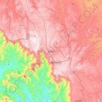
Name: Topografische Karte Al Bahah, Höhe, Relief.
Ort: Al Bahah, Al-Bahah Province, Saudi Arabia (19.85379 41.30564 20.17379 41.62564)
Durchschnittliche Höhe: 1.744 m
Minimale Höhe: 500 m
Maximale Höhe: 2.553 m
Al-Baha is the homeland of the Ghamid and Zahran tribes and is divided geographically into three distinct parts: Sarah, which contains the high Hijaz mountains characterized by temperate weather and rich plant cover due to relatively high annual rainfall, the Tihamah which is the lowland coastal area to the west of the Hejaz, characterized by very hot and humid weather and very little rainfall average, and the eastern hills characterized by an altitude of 1,550 to 1,900 metres (5,090 to 6,230 feet) above sea level with cool winters, hot summers and sparse plant cover. The largest city in the province, both in population and area, is Baljurashi, the second one is Al-Mandaq. In Tehama, there are two major cities: Qilwah and Al-Mikhwah. The number of tribes are 18, branching from the main ones, Ghamid and Zahran. The province has 13 settled tribes (working in trades and agriculture) and 5 nomadic tribes.
Andere topografische Karten
Klicken Sie auf eine Karte, um ihre Topografie, ihre Höhe und ihr Relief anzuzeigen.
Biljurashi
Saudi Arabia > Al-Bahah Province
Biljurashi, Al-Bahah Province, Saudi Arabia
Durchschnittliche Höhe: 1.528 m
القعر
Saudi Arabia > Al-Bahah Province
القعر, Al Mukhwah, Al-Bahah Province, Saudi Arabia
Durchschnittliche Höhe: 392 m
Al Aqiq
Saudi Arabia > Al-Bahah Province
Al Aqiq, Al-Bahah Province, Saudi Arabia
Durchschnittliche Höhe: 1.498 m
Al `Aqiq
Saudi Arabia > Al-Bahah Province
Al `Aqiq, Al Aqiq, Al-Bahah Province, Saudi Arabia
Durchschnittliche Höhe: 1.583 m
Al Bahah
Saudi Arabia > Al-Bahah Province
Al Bahah, Al-Bahah Province, Saudi Arabia
Durchschnittliche Höhe: 1.854 m