
Topografische Karte Franklin
Interaktive Karte
Klicken Sie auf die Karte, um die Höhe anzuzeigen.
Über diese Karte
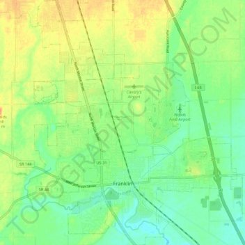
Name: Topografische Karte Franklin, Höhe, Relief.
Ort: Franklin, Johnson County, Indiana, 46131, United States (39.45993 -86.09377 39.54228 -86.00277)
Durchschnittliche Höhe: 230 m
Minimale Höhe: 214 m
Maximale Höhe: 250 m
Andere topografische Karten
Klicken Sie auf eine Karte, um ihre Topografie, ihre Höhe und ihr Relief anzuzeigen.
Nineveh
United States > Indiana > Johnson County
Nineveh, Johnson County, Indiana, United States
Durchschnittliche Höhe: 238 m
Trafalgar
United States > Indiana > Johnson County
Trafalgar, Johnson County, Indiana, United States
Durchschnittliche Höhe: 257 m
Greenwood
United States > Indiana > Johnson County
Greenwood, Johnson County, Indiana, United States
Durchschnittliche Höhe: 245 m
Bargersville
United States > Indiana > Johnson County
Bargersville, Johnson County, Indiana, 46106, United States
Durchschnittliche Höhe: 243 m
Edinburgh
United States > Indiana > Johnson County
Edinburgh, Johnson County, Indiana, United States
Durchschnittliche Höhe: 205 m
Stones Crossing
United States > Indiana > Johnson County > Greenwood
Stones Crossing, Greenwood, Johnson County, Indiana, 46143, United States
Durchschnittliche Höhe: 238 m
Green Valley
United States > Indiana > Johnson County > Greenwood
Green Valley, Greenwood, Johnson County, Indiana, 46143, United States
Durchschnittliche Höhe: 239 m