
Vielen Dank für die Unterstützung dieser Website ❤️
Spenden
Spenden
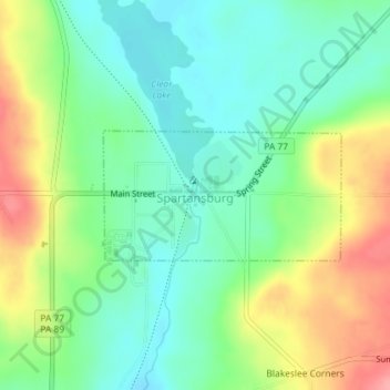
Topografische Karte Spartansburg
Klicken Sie auf die Karte, um die Höhe anzuzeigen.
Vielen Dank für die Unterstützung dieser Website ❤️
Spenden
Spenden
Spartansburg
Spartansburg Borough is located on the glaciated plateau of northwestern Pennsylvania. The borough is drained by East Branch Oil Creek, which begins at the outlet of Clear Lake, an impoundment of Patrick Run and Stranahan Run. The lowest elevation in Spartansburg is 1,430 ft (440 m) where East Branch Oil Creek flows south out of the borough. The highest elevation is 1,640 ft (500 m) at the southeastern corner of the borough.
Vielen Dank für die Unterstützung dieser Website ❤️
Spenden
Spenden
Über diese Karte
Name: Topografische Karte Spartansburg, Höhe, Relief.
Ort: Spartansburg, Crawford County, Pennsylvania, United States (41.81954 -79.69392 41.82855 -79.67178)
Durchschnittliche Höhe: 463 m
Minimale Höhe: 428 m
Maximale Höhe: 524 m
Vielen Dank für die Unterstützung dieser Website ❤️
Spenden
Spenden