
Topografische Karte Flint Hills Rodeo Grounds
Interaktive Karte
Klicken Sie auf die Karte, um die Höhe anzuzeigen.
Über diese Karte
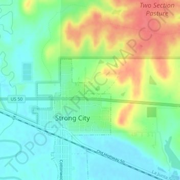
Name: Topografische Karte Flint Hills Rodeo Grounds, Höhe, Relief.
Durchschnittliche Höhe: 380 m
Minimale Höhe: 356 m
Maximale Höhe: 421 m
Andere topografische Karten
Klicken Sie auf eine Karte, um ihre Topografie, ihre Höhe und ihr Relief anzuzeigen.
Strong City
United States > Kansas > Chase County > Strong City > Strong City
Strong City, Chase County, Kansas, 66869, United States
Durchschnittliche Höhe: 381 m
Cottonwood Falls
United States > Kansas > Chase County > Cottonwood Falls > Cottonwood Falls
Cottonwood Falls, Chase County, Kansas, 66869, United States
Durchschnittliche Höhe: 379 m
Elmdale
United States > Kansas > Chase County > Elmdale
Elmdale, Chase County, Kansas, 66850, United States
Durchschnittliche Höhe: 369 m
Cottonwood Falls
United States > Kansas > Chase County
Cottonwood Falls, Chase County, Kansas, United States
Durchschnittliche Höhe: 369 m
Strong City
United States > Kansas > Chase County
Strong City, Chase County, Kansas, 66869, United States
Durchschnittliche Höhe: 370 m