
Topografische Karte Golden Gate Highlands National Park
Interaktive Karte
Klicken Sie auf die Karte, um die Höhe anzuzeigen.
Über diese Karte
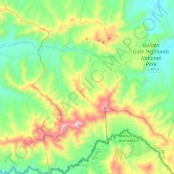
Name: Topografische Karte Golden Gate Highlands National Park, Höhe, Relief.
Durchschnittliche Höhe: 2.065 m
Minimale Höhe: 1.697 m
Maximale Höhe: 2.819 m
Andere topografische Karten
Klicken Sie auf eine Karte, um ihre Topografie, ihre Höhe und ihr Relief anzuzeigen.
Dihlabeng Ward 20
RSA > Free State > Dihlabeng Local Municipality
Dihlabeng Ward 20, Dihlabeng Local Municipality, Thabo Mofutsanyana District Municipality, Free State, 9707, RSA
Durchschnittliche Höhe: 1.975 m
Swartkrans
RSA > Free State > Dihlabeng Local Municipality
Swartkrans, Dihlabeng Local Municipality, Thabo Mofutsanyana District Municipality, Free State, RSA
Durchschnittliche Höhe: 2.036 m