
Vielen Dank für die Unterstützung dieser Website ❤️
Spenden
Spenden
Topografische Karte Shikaripura
Klicken Sie auf die Karte, um die Höhe anzuzeigen.
Vielen Dank für die Unterstützung dieser Website ❤️
Spenden
Spenden
Shikaripura
Shikaripur is located at 14°16′N 75°21′E / 14.27°N 75.35°E / 14.27; 75.35. It has an average elevation of 603 m (1978 ft). It lies on tropical forests of Malenadu region. Shikaripura is one of the junction to connect north karnataka to Malenadu. And the river kumadvati flows from the town and nearest dams anjanapura and ambligola, nearest tourist places balligavi,udutadi,jogfalls,lionsafori,agumbe,koodachadri,kavaledurga fort,bhadra river project, gajnur dam , sakrebaylu.
Vielen Dank für die Unterstützung dieser Website ❤️
Spenden
Spenden
Über diese Karte
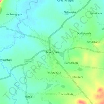
Name: Topografische Karte Shikaripura, Höhe, Relief.
Durchschnittliche Höhe: 610 m
Minimale Höhe: 580 m
Maximale Höhe: 716 m
Vielen Dank für die Unterstützung dieser Website ❤️
Spenden
Spenden