Topografische Karte Proctor
Klicken Sie auf die Karte, um die Höhe anzuzeigen.
Proctor
Proctor is adjacent to Duluth's Bayview Heights neighborhood, with which it forms something of a contiguous community unit due to Bayview Heights' topographical separation (the hill) from adjacent West Duluth. It is bounded by the city of Hermantown to the north, Midway Township to the west, Bayview Heights to the east, and a mostly undeveloped area of Duluth (officially in the Riverside neighborhood) to the south.
Über diese Karte
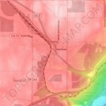
Name: Topografische Karte Proctor, Höhe, Relief.
Ort: Proctor, Saint Louis County, Minnesota, United States (46.72054 -92.23955 46.76425 -92.21687)
Durchschnittliche Höhe: 374 m
Minimale Höhe: 194 m
Maximale Höhe: 424 m
Andere topografische Karten
Klicken Sie auf eine Karte, um ihre Topografie, ihre Höhe und ihr Relief anzuzeigen.

Chris Lake
United States > Minnesota > Saint Louis County > Pequaywan Township
Durchschnittliche Höhe: 494 m
Embarrass
United States > Minnesota > Saint Louis County > Embarrass Township
Durchschnittliche Höhe: 438 m

Tower Junction
United States > Minnesota > Saint Louis County > Breitung Township > Soudan
Durchschnittliche Höhe: 437 m

Norway Creek
United States > Minnesota > Saint Louis County > Northeast St Louis
Durchschnittliche Höhe: 424 m


Central Lakes
United States > Minnesota > Saint Louis County > Ellsburg Township
Durchschnittliche Höhe: 408 m

Embarrass
United States > Minnesota > Saint Louis County > Embarrass Township
Durchschnittliche Höhe: 438 m


Echo River
United States > Minnesota > Saint Louis County > Northeast St Louis
Durchschnittliche Höhe: 393 m