
Topografische Karte Huanglong County
Interaktive Karte
Klicken Sie auf die Karte, um die Höhe anzuzeigen.
Über diese Karte
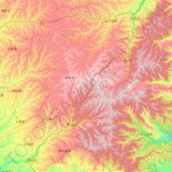
Name: Topografische Karte Huanglong County, Höhe, Relief.
Ort: Huanglong County, Yan'an, Shaanxi, China (35.40695 109.65546 36.03557 110.26765)
Durchschnittliche Höhe: 1.275 m
Minimale Höhe: 659 m
Maximale Höhe: 1.765 m
Huanglong County is located approximately 221 kilometres (137 mi) from Yan'an's urban core, and 226 kilometres (140 mi) from Xi'an's urban core. Located in the Loess Plateau, Huanglong County is hilly in elevation, ranging from 643.7 metres (2,112 ft) to 1,738 metres (5,702 ft) in height. A number of minor rivers run through the county. 87% of Huanglong County is forested, and the county is home to 1,012 species of plants and 225 species of animals.